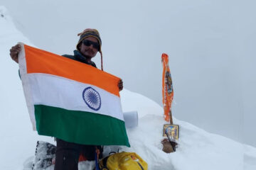
Rupin Pass is a high-altitude pass across the Himalayan mountain range in the state of Himachal Pradesh India. It lies on a traditional shepherd and hiking route which starts from Dhaula in Uttarakhand and ends in Sangla in Himachal Pradesh. The path itself is located across mostly uninhabited areas in the Himalayan ranges at an elevation of 15,250 ft (4,650M) above sea level.[1] Sarasvati Glacier at Sarasvotri at this pass has been identified by some sources as the origin of paleo-river Sarasvati which turned into icy waters at Netwar, flowing through Paonta Sahib and Adi Badri, Haryana, Punjab, Rajasthan, and Gujarat.
Description
Rupin Pass trek consists of trails dug out of rock faces and wooden bridges, cut through deep dark folds in the mountain, glaciers, and icy slopes, and over snow fields. Along the way, there are white Rhododendrons and an expanse of green meadows.
There are different trails that access the Rupin Pass. One of them starts at the sleepy village of Gosangu which is the last road head of Himachal Pradesh. Generally, trekkers and adventurers travel to Gosangu by road from Shimla via Rohru. The alternate route to Rupin Pass starts from Naitwar, which is accessible from Dehradun via Dhaula. From either of the two road heads, the first camp is Jhaka, the hanging village and the last stop for replenishing stocks and a look at the civilization. Traveling the Rupin Pass is a moderate – difficult level of climbing. The trails follow the Rupin river all the way to the top (Upper waterfall camp).
Rupin pass is unique in a way that the ice melting on one side of the pass forms the Rupin river that merges with Yamuna and eventually flows into the Bay of Bengal while the snow melting on the Sangla side of the pass merges into a stream that eventually flows into Sutlaj and hence flows into the Arabian sea.
Access
Rupin pass is at an altitude of 15250 ft above MSL and to reach here follow the Dhaula 5,100 ft to Gosangu 6,300 ft.11 km. Via Sewa – Gosangu 6,300 ft to Jhaka 8,700 ft.9 km Via Jiskun 7,600 ft. – Jhaka 8,700 ft to Saruwas thatch 11,150 ft. 6 km. Via Uduknal – Saruwas thatch 11,150 ft to thatch 11,680 ft (lower water fall camp) 6 km. – thatch 11,680 ft to the top of the Rupin waterfall 13,120 ft – thatch 11,680 ft to Rupin pass 15,250 ft.
Day 1. Dehradun – Mori (1100m) – Dhaula (1800m) (Drive/195 km) (7 -8 Hours)
Day 2. Dhaula (1800m) – Sewa (2100m) (Trek/3-4 hours)
Day 3. Sewa (2100m) – Jakha (2700m) (Trek/6-7 Hours)
Day 4. Jakha (2700m) – Suruwas Thach (3250m) (Trek/5-6 Hours)
Day 5. Suruwas Thach (3250m) – DhanderasThach (5 Km, 4 Hours)
Day 6. DhanderasThach – Upper Waterfall Camp (3 Hours with 2 Hours of Steep Climb)
Day 7. Upper Waterfall – Rupin Pass – Ronti Gad (10 Km, 11 Hours)
Day 8. Ronti Gad – Sangla (12 Km, 6 Hours)


Tour Reviews
There are no reviews yet.
Leave a Review